This itinerary focuses on the area that includes the Fuji Five Lakes (except for Lake Yamanaka) at the base of Mt. Fuji in Yamanashi Prefecture. Given how much there is to see and do in this area, you are encouraged to spend several days in the area and combine this itinerary with as many other "Yamanashi" itineraries, and/or "Festival" itineraries, as you like and have the time for. This itinerary, as proposed, will take one long day to see all the sites included so we would recommend that you plan to spend several days in the area and take advantage of one of the many accommodation options available, including possibly one mentioned below. Once you have selected this itinerary and saved it, you can change/customize it. If you plan to continue on, you can daisy-chain with other Yamanashi or other itineraries.
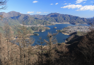
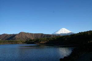
The name Fuji Five Lakes name comes from the fact that there are five lakes formed by previous eruptions of Mount Fuji. From west to east the lakes ("ko" in Japanese) are: Lake Motosu, Lake Shoji, Lake Saiko, Lake Kawaguchi (the main and largest lake), and Lake Yamanaka (the second biggest lake). Another feature of interest is the Aokigahara Jukai Forest, a dense forest growing out of an ancient lava field that flowed northwest from Mt. Fuji. In this area are various caves created by lava tunnels.
Given the time and distance from Tokyo (where most visitors will be coming from), we recommend taking the train from the Tokyo area (Shinjuku Station is the most direct starting point) to either the Otsuki Station or the Kawaguchiko Station. Both stations have several rental car outlets where you can reserve a car in advance.
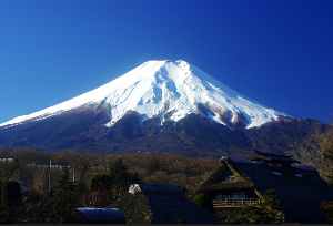
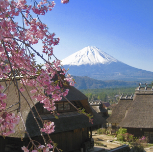
Mount Fuji (富士山, also called Fuji-san), is located on the main island of Honshū. It is the highest mountain in Japan, standing 3,776.24 m/12,389.2 ft. It is the second-highest volcano located on an island in Asia (after Mount Kerinci on the island of Sumatra), and seventh-highest peak of an island on Earth. Mount Fuji is an active stratovolcano that last erupted from 1707 to 1708. The mountain stands about 100 km/62 mi southwest of Tokyo and can be seen from there on clear days. It's exceptionally symmetrical cone, which is snow-capped for about 5 months of the year, is commonly used as a cultural icon of Japan and it is frequently depicted in many arts and photographs, as well as visited by sightseers and climbers during the climbing season in July and August.
Mount Fuji is one of Japan's "Three Holy Mountains" along with Mount Tate and Mount Haku. It is a Special Place of Scenic Beauty and one of Japan's Historic Sites.[7] It was added to the World Heritage List as a Cultural Site on June 22, 2013.[7] According to UNESCO, Mount Fuji has "inspired artists and poets and been the object of pilgrimage for centuries". UNESCO recognizes 25 sites of cultural interest within the Mount Fuji locality. These 25 locations include the mountain and the Shinto shrine, Fujisan Hongū Sengen Taisha, as well as the Buddhist Taisekiji Head Temple founded in 1290, later depicted by Japanese ukiyo-e artist Katsushika Hokusai. Courtesy of Wikipedia
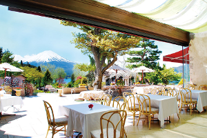
ACCOMMODATIONS: There is a large variety of adequate and more than adequate accommodation options in the Fuji Five Lakes area of Yamanashi Prefecture where you can spend 1-3 nights. One of the most unique options is to spend 1-2 nights at the upscale but unique Hoshinoya Fuji (MapCode: 59 089 594*36). Another high-end ryokan is the Kozantei Ubuya (MapCode: 161 332 139*00). If you have the time you could spend a night at a lodging at each of the 5 lakes.
You can also easily reverse this itinerary, if you wish, just by following the MapCodes in the reverse order.
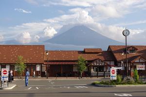
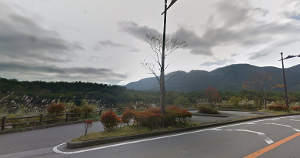
Kawaguchiko Station is the most centrally located railway gateway to the Mt. Fuji, Fuji Five Lakes region. It has both a Toyota and a Nippon Rent-A-Car outlet within a block or two of the station (in addition to several local brands) so it is a good place to start your Mt. Fuji area adventure. It takes about 2 hours by train from Shinjuku Station in Tokyo to Kawaguchi-ko Station with several express through trains but mostly requiring a change of trains in Otsuki Station.
The Kawaguchiko Station (河口湖駅, Kawaguchiko-eki) is a railway station on the Fujikyuko Line in Fujikawaguchiko, Yamanashi Prefecture. It is conveniently located in the center of the Fuji Five Lakes region near the base of Mt. Fuji. It has a tourist information center attached. There are a variety of rental car outlets in the area.
The station forms the terminus of the 26.6 km/16.5 mi privately operated Fujikyuko Line from Ōtsuki. The station is staffed and consists of two island platforms serving three tracks, numbered 1 to 3. Passengers access the platforms via a level crossing. It has waiting rooms and toilet facilities. It is located at an altitude of 857 m/2,812 ft. In fiscal 2015, the station was used by an average of 2903 passengers daily.
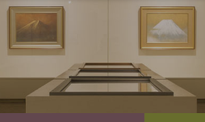
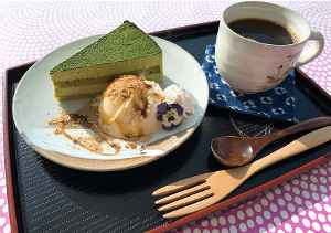
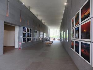
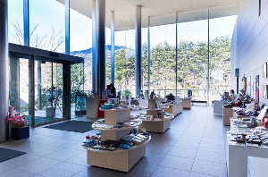
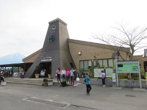
The Kawaguchiko Museum of Art focuses on several themes. In particular it showcases art showing Mt. Fuji. It has annual exhibitions and competitions, including in photography. Although not large the artwork is worth a visit and there is a relaxing cafe in the museum as well.
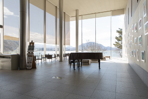
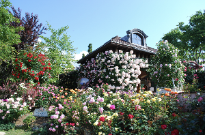
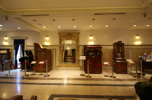
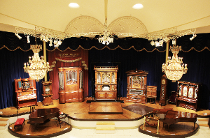
When you step inside the Kawaguchiko Music Forest Museum, you will feel like you are in a "small European country without a passport." It is a paradise of music and flowers where you can enjoy world-famous music boxes and self-playing musical instruments, in particular, the automatically-playing musical instruments and the world's largest dance organ, which was scheduled to be installed on the luxury liner "Titanic", reproduce the sounds that revive over time. There are flowers that can be enjoyed in each season, including one of Japan's leading rose gardens. The two major shows, "Sand Art Live" and "Collaboration Concert with Auto-playing Musical Instruments and Opera Singer" are a must see!
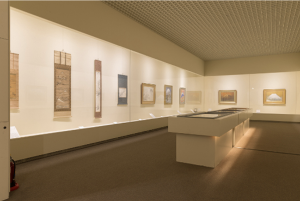
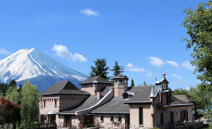
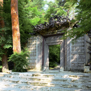
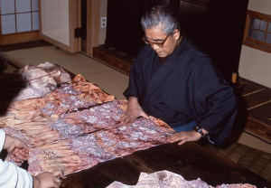
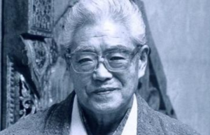
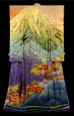
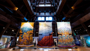
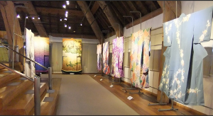
The Itchiku Kubota Art Museum was built in 1994 by Itchiku Kubota (1917-2003) a celebrated textile dyer, for the permanent exhibition of his work. In addition to the works, all the gardens and buildings represent the world of Itchiku. The uniqueness of the museum makes this a "must see" in Kawaguchiko. The buildings themselves were inspired by Gaudi.
There is an exhibition of about 30 kimonos that incorporate dyeing techniques from the Muromachi period (1336-1573) called “Tsuji-ga-Hana” that are fascinating with their fine and majestic designs. The works are rotated by seasons, and the kimonos are displayed in line with each theme, such as the “Four Seasons”, "Space”, etc. The famouse Japanese artist (Takamizawa of THE ALFEE) used the Kimono in one of his concerts. Also other Kimono was used in the Takarazuka Revue.
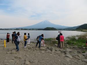
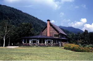
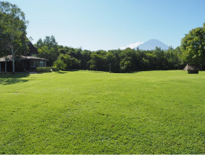
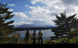
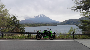
Oshi Park is probably the best viewing spot to see Mt. Fuji across Lake Kawaguchi. It is located next to the Kawaguchiko Natural Living Center so there is plenty of parking, food, and shopping. There is even a small local market with local produce for sale (http://www.seikatsukan.jp/; Tel: 0555-76-8230; open daily 09:00-18:00).
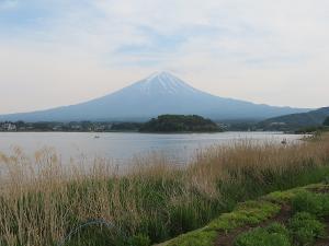
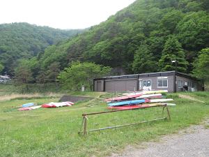
The Lake Sai Park is located right along Highway #21 that follows the north shore of both Lake Kawaguchi and Lake Saiko. (Sai-ko or Saiko, actually means "west lake".) This is picturesque stopping point for photos or just to relax. There is a boat rental shop and a small restaurant across the street.
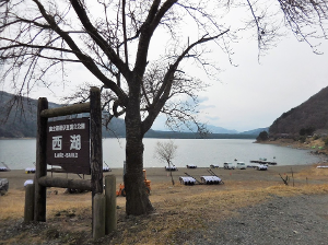
Western Lake (西湖, Saiko), sometimes Saiko, is one of the Fuji Five Lakes and located in the town of Fujikawaguchiko in southern Yamanashi Prefecture near Mount Fuji, Japan.
It is the fourth of the Fuji Five Lakes in terms of surface area, and second deepest, with a maximum water depth of 71.1 metres (233 ft).[1] Its surface elevation of 900 metres (3,000 ft) is the same as for Lake Motosu and Lake Shōji, confirming that these three lakes were originally a single lake, which was divided by an enormous lava flow from Mount Fuji during an eruption from 864 to 868 AD.[2] The remnants of the lava flow are now under the Aokigahara Jukai Forest, and there is evidence to indicate that these three lakes remain connected by underground waterways.[1]
The lake is within the borders of the Fuji-Hakone-Izu National Park.[3]
Saiko has no natural drainage, but an artificial channel now connects it to Lake Kawaguchi. As with the other Fuji Five Lakes, the area is a popular resort, with many lakeside hotels, windsurfing facilities, camp sites, and excursion boats. Japanese crucian carp, wakasagi and Kunimasu were introduced to the lake in the Meiji period, and sports fishing is also popular.
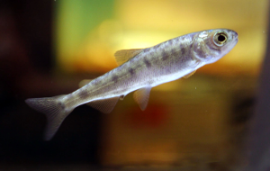
However, Kunimasu, which had been introduced to a number of lakes in Japan in the Taishō period were believed to have died out and become extinct, with the last reported sighting in 1935, until rediscovered in Lake Sai in 2010.[4]
West Lake in Hangzhou, China, is written with the same kanji as Lake Sai.
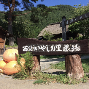
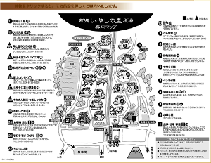
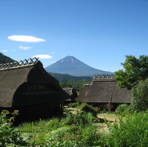
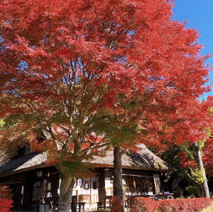
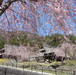
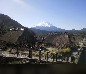
The Saiko Iyashi-no-Sato Nenba is a reconstructed Japanese village showing old traditional architecture and way of life. The farm houses are built in the gassho-zukuri (praying hands) style. There are beautiful views of the village with Mt. Fuji in the background in all four seasons.
If you have seen this kind of traditional Japanese village elsewhere in Japan you can skip it on this itinerary.
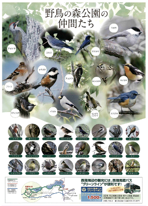
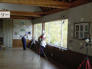
The Saiko Wild Bird Forest Park is located in the Aokigahara Forest where over 200 species of wild birds visit. There is a nature center and a bird watching room equipped with a telescope, a workshop for woodworking, and an exhibition room. It is recommended that one spend some time at the park so you can listen slowly to the chirping of wild birds.
Coming west from Lake Sai via Highway #139, turn north on Highway #358. The Lake Shoji View Point is ahead on your left (lake-side) about 300 m/984 ft.
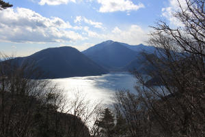
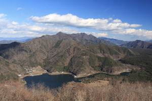
Lake Shōji (精進湖, Shōji-ko) is the one of the Fuji Five Lakes. It is the smallest of the Fuji Five Lakes in terms of surface area, and the third deepest, with a maximum water depth of 15.2 m/50 ft. Its surface elevation of 900 m/3000 ft is the same as for Lake Motosu and Lake Sai. This confirms that these three lakes were originally a single lake which was divided by an enormous lava flow from Mt. Fuji during an eruption from 864-868 AD. The remnants of the lava flow are now under the Aokigahara Jukai Forest. There is evidence to indicate that these three lakes remain connected by underground waterways.
The lake is within the borders of the Fuji-Hakone-Izu National Park. As with the other Fuji Five Lakes, the area is a popular resort, with many lakeside hotels, windsurfing facilities, camp sites, and excursion boats. Japanese crucian carp and wakasagi were introduced to the lake in the Meiji period, and sports fishing is also popular. The water of the lake lacks transparency and has a tendency towards a greenish hue due to algae. Rental boats are available along the shore to rent.
Lake Shōji is given the name "Switzerland of East Asia" because Englishmen in the Meiji Era explored around the base of Mount Fuji, and remarked that the view of the mountain was most beautiful from Lake Shoji. The placid lake is rich in nutrients which include plankton.
Courtesy of Wikipedia
Hours :
Open daily 24/7
Address :
Lake Shōji, Shoji, Fujikawaguchiko, Minamitsuru District, Yamanashi 401-0336
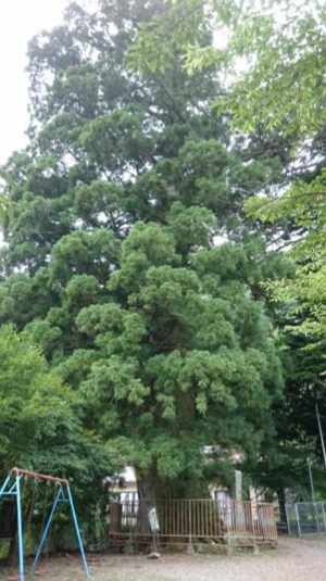
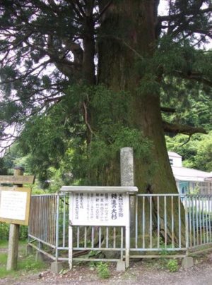
The Old Cedar of Shoji is located with the precincts of the Suwa Shrine on the north coast of Lake Shoji. It is a large cedar tree designated as a National Natural Monument. The tree is about 1200 years old. It is about 10 m/33 ft in circumference and is 40 m/131 ft high. It is the largest tree in the prefecture. It is also known as "Sennen Cedar" and is known as a sacred tree.
11.
Lake Shoji & Tatego Beach - Parking - Shojiko Kenei Parking Lot
Courtesy of Walter L. Keats
Courtesy of Wikipedia
Courtesy of Wikipedia
Courtesy of Walter L. Keats
Courtesy of Walter L. Keats
Min/Max Time :
10 / 20
Minutes
MapCode :
312 567 595*88
Description :
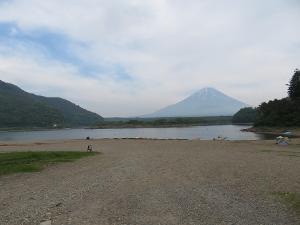
Coming north on Highway #358 around the east side of Lake Shoji, then continue on west on Highway #706. The Lake Shoji & Tatego Beach parking lot is ahead on your right (town-side). You can view the lake and Mt. Fuji from the parking area or cross the street and view it from the beach. The area around the parking lot has several restaurants.
Lake Shōji (精進湖, Shōji-ko) is the one of the Fuji Five Lakes. It is the smallest of the Fuji Five Lakes in terms of surface area, and the third deepest, with a maximum water depth of 15.2 m/50 ft. Its surface elevation of 900 m/3000 ft is the same as for Lake Motosu and Lake Sai. This confirms that these three lakes were originally a single lake which was divided by an enormous lava flow from Mt. Fuji during an eruption from 864-868 AD. The remnants of the lava flow are now under the Aokigahara Jukai Forest. There is evidence to indicate that these three lakes remain connected by underground waterways.
The lake is within the borders of the Fuji-Hakone-Izu National Park. As with the other Fuji Five Lakes, the area is a popular resort, with many lakeside hotels, windsurfing facilities, camp sites, and excursion boats. Japanese crucian carp and wakasagi were introduced to the lake in the Meiji period, and sports fishing is also popular. The water of the lake lacks transparency and has a tendency towards a greenish hue due to algae. Rental boats are available along the shore to rent.
Lake Shōji is given the name "Switzerland of East Asia" because Englishmen in the Meiji Era explored around the base of Mount Fuji, and remarked that the view of the mountain was most beautiful from Lake Shoji. The placid lake is rich in nutrients which include plankton.
Courtesy of Wikipedia
Hours :
Open daily 24/7
Address :
298 Shōji, Fujikawaguchiko, Minamitsuru-gun, Yamanashi 401-0336, Japan
7.7
km / 4.8
miles
-
(11
minutes)
12.
Lake Motosu Viewing Spot - 本栖湖駐車場
Courtesy of Google Maps & 松本貞典
Courtesy of Google Maps & 杉本哲哉
Courtesy of Google Maps & depp chau
Min/Max Time :
5 / 10
Minutes
MapCode :
312 505 538*28
Description :
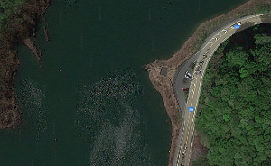
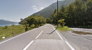
Continue south on Highway #706 along the west side of Lake Shoji, rejoining Highway #139 going west. Then take Highway #300 north along the east shore of Lake Motosu. The Lake Motosu Viewing Spot is just a parking strip on the shoulder of the road. You can view the lake and Mt. Fuji from here. Be careful crossing the road!
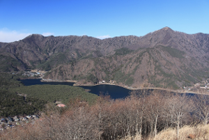
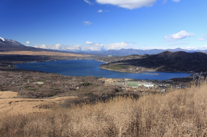
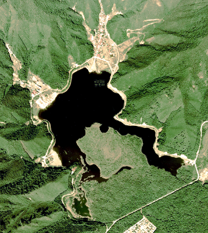
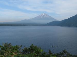
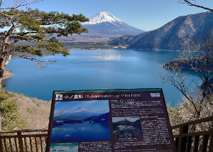
Lake Motosu (本栖湖, Motosu-ko) is the westernmost of the Fuji Five Lakes and is located on the border of the towns of Fujikawaguchiko and Minobu in southern Yamanashi Prefecture near Mount Fuji. The lake is within the borders of the Fuji-Hakone-Izu National Park. It is the third-largest of the Fuji Five Lakes in terms of surface area but it is the deepest, with a maximum water depth of 121.6 m/399 ft, making it the ninth-deepest lake in Japan. Its surface area of 4.7 sq km/1.8 sq mi and a total water volume of 0.316 cubic km/256,000 acre ft means that it is one of the largest lakes in Japan by capacity due to its great depth. The elevation of 900 m/3000 ft is the same as for Lake Shōji and Lake Sai. This confirms that these three lakes were originally a single lake, which was divided by an enormous lava flow from Mount Fuji. The remnants of the lava flow are now under the Aokigahara Jukai Forest, and there is evidence to indicate that these three lakes remain connected by underground waterways. The temperature of the water never drops below 4 °C/39 °F), making it the only one of the Fuji Five Lakes that does not freeze in winter.
As with the other Fuji Five Lakes, the area is a popular resort, with many lakeside hotels, windsurfing facilities, camp sites, and excursion boats. Rainbow trout and brown trout were introduced to the lake in the Meiji period, and sports fishing is also popular. However, in recent years, reduced water transparency due to pollution from these activities has been a growing issue.
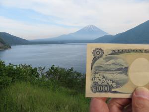
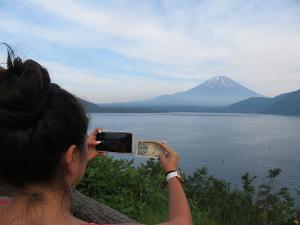
The lake and its view of Mount Fuji, as captured by photographer Koyo Okada (1895-1971) were featured on the Series D of the Japanese 5000-yen note (in 1984) and currently on the Series E of the Japanese 1000-yen note (in 2004). There is a little "observation" park (MapCode: ) at the northwest side of the lake where you can replicate the view.
Courtesy of Wikipedia
Hours :
Open daily 24/7
Address :
Lake Motosu, Yamanashi 401-0337
1.3
km / 0.8
miles
-
(2
minutes)
13.
Tenbo (Observation) Park - 展望公園
Courtesy of Walter L. Keats
Courtesy of Walter L. Keats
Courtesy of Walter L. Keats
Courtesy of Walter L. Keats
Min/Max Time :
10 / 20
Minutes
MapCode :
312 504 463*63
Description :
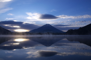
The Tenbo (Observation) Park is the location where the view of Mt. Fuji on the Japanese 1000 Yen note was taken. Many visitors take a picture of Mt. Fuji while holding up that side of the banknote in the same image. (Note there are public pay toilets a little further along Highway #709.
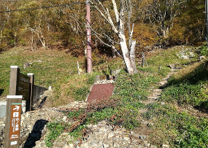
The Nakanokura Pass View Point (MapCode: 312 504 604*22) provides spectacular views of Lake Motosu and Mt. Fuji. If you are lucky and the weather is just right you can see a perfect inverted reflection of Mt. Fuji on the lake.
There are steps and a path leading up to the view point (approximately 30 mins. each way minimum) starting next to a public toilet with parking spaces, just a short distance to the east of the parking area.
This Lake Motosu "Way-Point" has been added to ensure that you are directed to make a complete circle of Lake Motosu. Without it the navigation system might send you back the way you came as being the "shorter" route. This way-point is near a campground. Once you reach this point just stop and enter the your next MapCode.
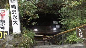
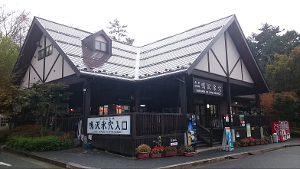
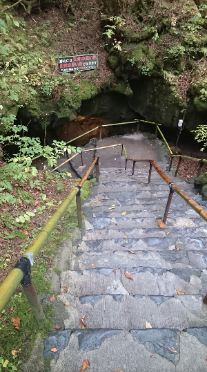
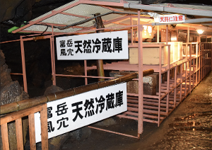
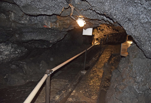
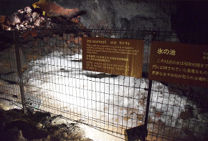
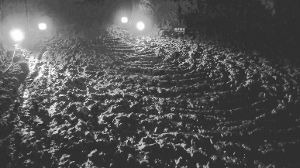
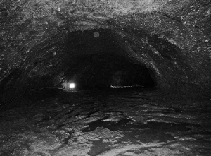
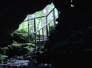
The Narusawa Ice Cave is in an ancient lava tube in the Aokigahara Forest which was created by a lava flow from an eruption of Mt. Fuji in 864 (that also created Lake Shoji and Lake Sai). The cave is 1 of the 3 major caves in the Aokigahara Forest area. The others are the Fugaku Wind Cave (MapCode: 689 484 816*11), and the Lake Sai Bat Cave (MapCode: 689 545 838*03); all 3 were designated National Monuments of Japan in 1929). It is 156 m/512 ft long with two lobes. It has a width of 1.5-11 m/5-36 ft and the height of 1-3.6 m/3-12 ft. The average temperature inside the cave is about 3° C/37° F. The cave was long used as a natural refrigerator. During the Edo period (1603-1868) ice cut in this cave was sent to the shōgun and his entourage in Edo. During the early 1900s ice made here was used in refrigerators before the electric refrigerator arrived.
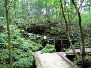
The Fugaku Wind Cave is in an ancient lava tube in the Aokigahara Forest which was created by a lava flow from an eruption of Mt. Fuji in 864 (that also created Lake Shoji and Lake Sai). The cave is one of the 3 major caves in the Aokigahara Forest area. The others are the Lake Sai Bat Cave (MapCode: 689 545 838*03), and the Narusawa Ice Cave (MapCode: 689 485 582*60); all 3 were designated National Monuments of Japan in 1929). It is 201 m/659 ft long with an average height of 8.7 m/29 ft. Its name derives from Fugaku (富岳), a literary name for Mt. Fuji (富士山), and Fūketsu (風穴) for wind cave because there is enough circulation of air on the cave. The walls of the cave are mostly made of basalt. Inside the cave, there are icicles even in summer, lava terraces and rope-like lava forms. From the Edo period to the Meiji period (1603 to 1912) this cave was used to keep silk worm eggs.
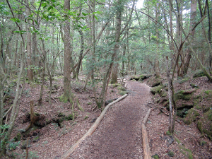
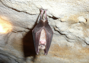
The Lake Sai Bat Cave is in an ancient lava tube in the Aokigahara Forest which was created by a lava flow from an eruption of Mt. Fuji in 864 (that also created Lake Shoji and Lake Sai). There is a walk through an interesting part of the forest to get to the cave entrance and then stairs to climb down into the cave. The cave is the longest of the 3 major caves in Aokigahara. The others are the Fugaku Wind Cave (MapCode: 689 484 816*11), and the Narusawa Cave (MapCode: 689 485 582*60); all 3 were designated National Monuments of Japan in 1929). It is located at 925 m/3035 ft above sea level and is 386.5 m/1268 ft long.
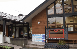
The Lake Sai Nature Center is located next to the entrance to the Bat Cave. Walking tours through Aokigahara Forest can be arranged with Fujikawaguchiko, Yamanashi-approved tour guides. Next to the Nature Center is an exhibition hall of Kunimasu trout which was declared extinct around 1945 in Lake Tazawa, Akita Prefecture in northern Honshu but was then discovered in Lake Sai in 2010.
The Kawaguchiko Station Parking Lot is a large parking lot connected to Kawaguchiko Station, right in the center of Kawaguchiko. There are numerous restaurants, shops and other facilties nearby. The station has a restaurant, vending machines and toilets.