MapCode :
357 450 236*03
Description :
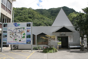
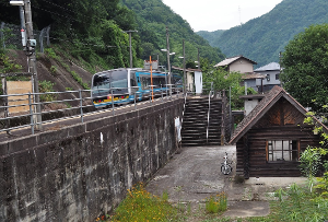
The Awa-Kawaguchi Station is used here only as a starting point or "way-point" for itineraries in Oboke and the Iya River Valley. There are no parking spaces or rental car facilities here.
The Awa-Kawaguchi Station (阿波川口駅, Awa-Kawaguchi-eki) is a railway station on the Dosan Line in Miyoshi, Tokushima Prefecture. It is operated by JR Shikoku. The station consists of two side platforms serving two tracks. A footbridge connects the two platforms. The station building has a waiting room and a ticket window. The station opened on 28 November 1935 when the then Kōchi Line was extended northwards from Toyonaga to Minawa and the line was renamed the Dosan Line. At this time the station was operated by Japanese Government Railways, later becoming Japanese National Railways (JNR). With the privatization of JNR on 1 April 1987, control of the station passed to JR Shikoku.
Courtesy of Wikipedia
Address :
Yamashirocho Okawamochi, Miyoshi, Tokushima 779-5304
5.8
km / 3.6
miles
-
(8
minutes)
Min/Max Time :
5 / 20
Minutes
MapCode :
357 361 825*63
Description :
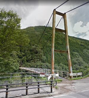
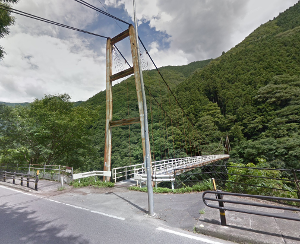
The Koboke Gorge Suspension Bridge There is a parking area on the shoulder of the northbound lane (hill side) a little south of the bridge.
Hours :
Open daily 24/7
Address :
Yamashirocho Shigezane, Miyoshi, Tokushima 779-5322
1.7
km / 1.1
miles
-
(2
minutes)
Min/Max Time :
5 / 15
Minutes
MapCode :
357 331 310*28
Phone :
012-040-4344
Description :
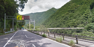
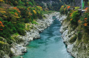
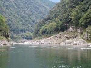
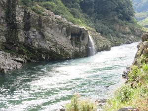
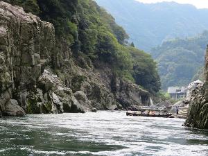
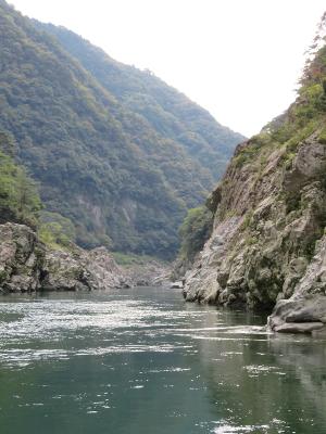
The Koboke Gorge of the Yoshino River has unusual geological strata, including a rudaceous schist formation designated as a natural monument. The Yoshino River has cut through the Shikoku Mountains over the ages, eroding crystalline schist into winding gorges with myriad shapes and forms, which almost look like marble statues. With fantastic reflections of cherry blossoms in spring and full autumn color in season, the river is host to a number of boating activities, from relaxing cruise down the calm part of the river, to an exciting rafting trip down the rapids. Koboke gorge lies 3 km/2 mi downstream of Oboke and its scale is a little more modest than Oboke Gorge, but is still beautiful and fascinating because of the rare shaped rock and its sandstone beauty.
Note: There are several shoulder areas suitable for parking on the west side of Highway 32 in this area. Be careful crossing the road!
Note: There are several shoulder areas suitable for parking on the west side of Highway 32 in this area. Be careful crossing the road!
Hours :
Open daily 24/7
Address :
Habiro Ikedacho Kawasaki, Miyoshi, Tokushima 779-5166
4.6
km / 2.9
miles
-
(5
minutes)
Min/Max Time :
5 / 15
Minutes
MapCode :
357 181 662*17
Phone :
088-372-3910
Description :
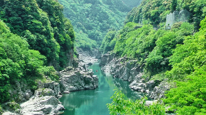
The Oboke Gorge of the Yoshino River has unusual geological strata, including a rudaceous schist formation designated as a natural monument. The Yoshino River has cut through the Shikoku Mountains over the ages, eroding crystalline schist into winding gorges with myriad shapes and forms, which almost look like marble statues. With fantastic reflections of cherry blossoms in spring and full autumn color in season, the river is host to a number of boating activities, from relaxing cruise down the calm part of the river, to an exciting rafting trip down the rapids. Koboke Gorge lies 3 km/2 mi downstream (north) of Oboke and its scale is a little more modest than Oboke, but is still beautiful and fascinating because of the rare shaped rock and its sandstone beauty.
Note: There are several shoulder areas suitable for parking on the west side of Highway 32 in this area. Be careful crossing the road!
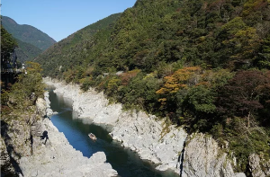
If you have more time, the Oboke Gorge Sightseeing Boat (MapCode: 357 151 736*77) travels down and then back the Yoshino River in about 30 minutes, offering the passengers scenic vistas of the grandeur of nature's handiwork as they glide through the ravine. Crystalline schist resembling marble sculptures rises above the boat on both sides, giving tourists an awesome sight. You will enjoy the changing season through fresh green in summer, coloured leaves in autumn and even snow in winter (https://www.mannaka.co.jp/restaurant/excursionship/excursionship.html).
Note: There are several shoulder areas suitable for parking on the west side of Highway 32 in this area. Be careful crossing the road!
If you have more time, the Oboke Gorge Sightseeing Boat (MapCode: 357 151 736*77) travels down and then back the Yoshino River in about 30 minutes, offering the passengers scenic vistas of the grandeur of nature's handiwork as they glide through the ravine. Crystalline schist resembling marble sculptures rises above the boat on both sides, giving tourists an awesome sight. You will enjoy the changing season through fresh green in summer, coloured leaves in autumn and even snow in winter (https://www.mannaka.co.jp/restaurant/excursionship/excursionship.html).
Hours :
Open daily 24/7
Address :
Yamashirocho Shigezane, Miyoshi, Tokushima 779-5322
1.0
km / 0.6
miles
-
(1
minutes)

Min/Max Time :
45 / 60
Minutes
MapCode :
357 151 736*77
Phone :
088-384-1211
Website :
Description :
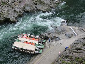
The Oboke Gorge Sightseeing Boat travels down and then back up the Yoshino River in about 30 minutes, offering the passengers scenic vistas of the grandeur of nature's handiwork as they glide through the Oboke Gorge. Crystalline schist resembling marble sculptures rises above the boat on both sides, giving tourists an awesome sight. You will enjoy the changing season through fresh green in summer, colored leaves in autumn and even snow in winter.
Hours :
Open daily 09:00 – 15:30
Address :
1520 National Route 32, Yamashirochō Nishiu, Miyoshi, Tokushima 779-5451
0.6
km / 0.4
miles
-
(1
minutes)
Min/Max Time :
15 / 30
Minutes
MapCode :
357 151 420*06
Description :
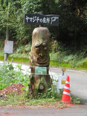
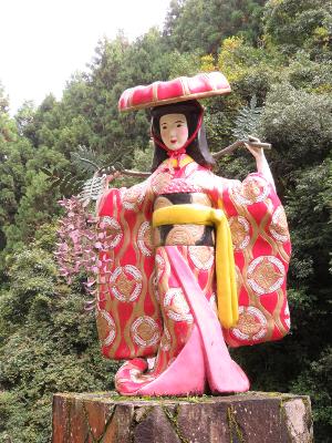
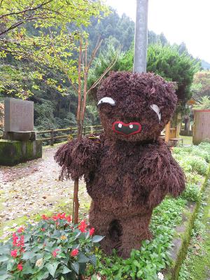
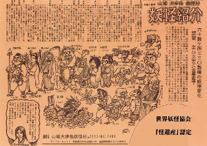
The Yokai (Hobgoblin) Road is a section, about 1.6 km/1 mi long, of Highway #272 along the north side of the Fujikawadani River. It starts a little west of Highway #32, where the Fujikawadani flows into the Yoshino River. This mountainous area of Yamashiro Town is famous for its secluded nature and mysterious history linked up with the Heike Clan samurai, many of whom, after losing the Genpei War (1180-1185) were forced into hiding in this rugged area to avoid being hunted down and killed. Possibly related to this history, the area is also famous for it's Yokai (Hobgoblin) legends which are fairly unique in the country. It is said that the hobgoblins or peculiar phenomenon were sometimes said to be a reminder to people to be diligent in general lives and also to respect nature and the environment. These legends together with effort of local people trying to energize the community through a unique and fun theme was recognized and acknowledged as “Yokai Heritage” by the World Yokai Society on May 25, 2008. This is the Society's second acknowledgement in its history after Sakaiminato City in Tottori Prefecture. These Yokai are manifested in as many as 100 carved statues along the road and the nearby Yoshino Village. Every autumn there is a Yohai Festival held in Yoshino Village.
Note: If you need more interaction with Yokai you can also visit the Yokai House and Geology Museum a little further south on Highway #32 in the Oboke Michi-no-Eki road station.
Note: If you need more interaction with Yokai you can also visit the Yokai House and Geology Museum a little further south on Highway #32 in the Oboke Michi-no-Eki road station.
Hours :
Open daily 24/7
Address :
Yamashiro-cho Nishiu, Miyoshi City, Tokushima 779-5451
1.5
km / 0.9
miles
-
(2
minutes)
Min/Max Time :
5 / 20
Minutes
MapCode :
207 179 249*82
Description :
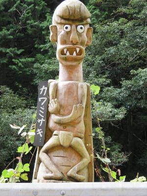
The represents the western end of the Yokai (Hobgoblin) Road with its approximately 60 carved statues of Yokai of various kinds. It is about 1.6 km/1 mi from the starting point at the eastern end of Highway #272 along the north side of the Fujikawadani River.
This mountainous area of Yamashiro Town is famous for its secluded nature and mysterious history linked up with the Heike Clan samurai, many of whom, after losing the Genpei War (1180-1185) were forced into hiding in this rugged area to avoid being hunted down and killed. Possibly related to this history, the area is also famous for it's Yokai (Hobgoblin) legends which are fairly unique in the country. It is said that the hobgoblins or peculiar phenomenon were sometimes said to be a reminder to people to be diligent in general lives and also to respect nature and the environment. These legends together with effort of local people trying to energize the community through a unique and fun theme was recognized and acknowledged as “Yokai Heritage” by the World Yokai Society on May 25, 2008. This is the Society's second acknowledgement in its history after Sakaiminato City in Tottori Prefecture. These Yokai are manifested in as many as 60 carved statues along this and nearby sections of the road.
Note: If you need more interaction with Yokai you can also visit the Yokai House and Geology Museum a little further south on Highway #32 in the Oboke Michi-no-Eki road station.
Hours :
Open daily 24/7
Address :
Yamashirocho Kamimyo, Miyoshi, Tokushima 779-5452
2.1
km / 1.3
miles
-
(3
minutes)

Min/Max Time :
10 / 30
Minutes
MapCode :
357 151 345*77
Phone :
088-384-1489
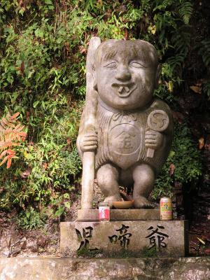
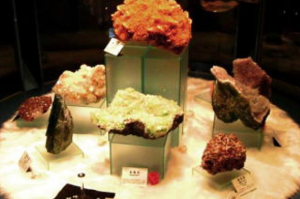
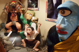
Description :
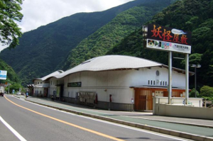
The Yokai (Hobgoblin) House & Geology Museum is located in the Oboke Michi-no-Eki on Highway #32. This mountainous area of Yamashiro Town is famous for its secluded nature and mysterious history linked up with the Heike Clan samurai, many of whom, after losing the Genpei War (1180-1185) were forced into hiding in this rugged area to avoid being hunted down and killed. Possibly related to this history, the area is also famous for it's Yokai (Hobgoblin) legends which are fairly unique in the country. It is said that the hobgoblins or peculiar phenomenon were sometimes said to be a reminder to people to be diligent in general lives and also to respect nature and the environment. These legends together with effort of local people trying to energize the community through a unique and fun theme was recognized and acknowledged as “Yokai Heritage” by the World Yokai Society on May 25, 2008. This is the Society's second acknowledgement in its history after Sakaiminato City in Tottori Prefecture. In addition to interacting with Yokai you can also learn about the geology of the area.
Note: The Yokai are also manifested in as many as 60 carved statues along a nearby section of Highway #272 called the Yokai (Hobgoblin) Road (MapCode: 357 151 420*06).
Note: The Yokai are also manifested in as many as 60 carved statues along a nearby section of Highway #272 called the Yokai (Hobgoblin) Road (MapCode: 357 151 420*06).
Hours :
Open daily 09:00 - 17:00
Address :
1553-1, Yamashirocho Kamimyo, Miyoshi, Tokushima, 779-5452
4.6
km / 2.9
miles
-
(7
minutes)

Min/Max Time :
10 / 45
Minutes
MapCode :
357 154 512*22
Description :
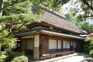
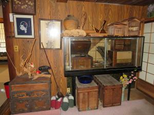
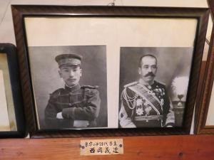
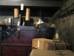
The Heike Yashiki Museum of Folklore exhibits materials and relics of Heike Clan. This has been a residence of the descendant of Horikawa Naiki, who was a private doctor to the young Emperor Antoku. He has entered into this remote mountain with the remaining members of Heike Clan after they lost the Genpei War (1180-1185). He served as a doctor as well as an oracle in the Iya region, where medicinal herbs were plentiful. In its garden stands an 800 years old tree and in the museum building, the inside of which remains as it did in the Edo period (1603-1868), are exhibits of armor, flags, ancient documents, and other materials.
Hours :
Open daily 08:00 – 17:00
Address :
46 Nishiiyayamamura Nishioka, Miyoshi, Tokushima 778-0105
4.4
km / 2.8
miles
-
(7
minutes)
Min/Max Time :
10 / 90
Minutes
MapCode :
357 188 480*14
Phone :
088-376-8585
Website :
Description :
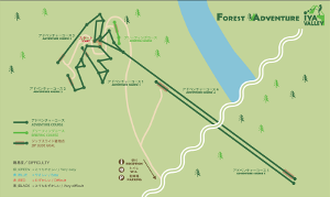
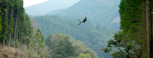
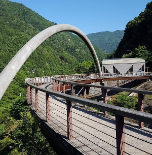
The Iya Fureai Park has several parts. In addition to a wooden playground area and a waterfront promenade, it has a "ladybug mono-rider" (a small monorail system), and a camping site. It also has the "Iya Roman Bridge", a walking bridge that offers spectacular views of the valley.
The final part is the “Forest Adventure Iya Valley”, consisting of 5 "Adventure Course" zip-lines, opened in 2017. One zip-line exceeds 360 m/1181 ft in length (https://fa-iya.foret-aventure.jp/eng/).
The final part is the “Forest Adventure Iya Valley”, consisting of 5 "Adventure Course" zip-lines, opened in 2017. One zip-line exceeds 360 m/1181 ft in length (https://fa-iya.foret-aventure.jp/eng/).
Hours :
Open daily 09:00 – 17:00
Address :
379 Nishiiyayamamura Oinouchi, Miyoshi, Tokushima 778-0101
6.0
km / 3.7
miles
-
(13
minutes)
Min/Max Time :
5 / 15
Minutes
MapCode :
357 308 376*22
Phone :
012-040-4344
Description :
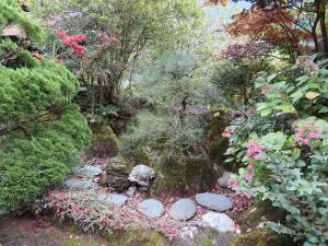
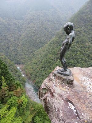
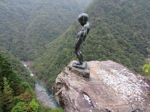
The Statue of a Peeing Boy is located in an area with a of dizzying succession of sheer cliffs lining the steep gorge carved out of the mountains by the Iya River. This majestic and beautiful valley stretches out for 20 km/12 mi and cliffs at the height of several dozen to hundreds of meters will be covered by fresh vegetation in spring and beautiful foliage in autumn. When looking down at the winding emerald green river from the cliff top, you may feel dizzy as it looks far below, but offers you the beautiful view of river curves along its rim. As a symbol of innocent courage, a statue of a peeing boy stands at the edge of a 200 m/656 ft precipice, which is noted as the most dangerous spot in the Iya River Valley. In the old days, local children and travelers stood up here and urinated to show their bravado.
Hours :
Open daily 24/7
Address :
Matsuo Ikeda-cho, Miyoshi, Tokushima 778-0165
3.6
km / 2.2
miles
-
(9
minutes)
Min/Max Time :
5 / 15
Minutes
MapCode :
357 248 616*88
Description :
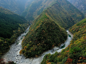
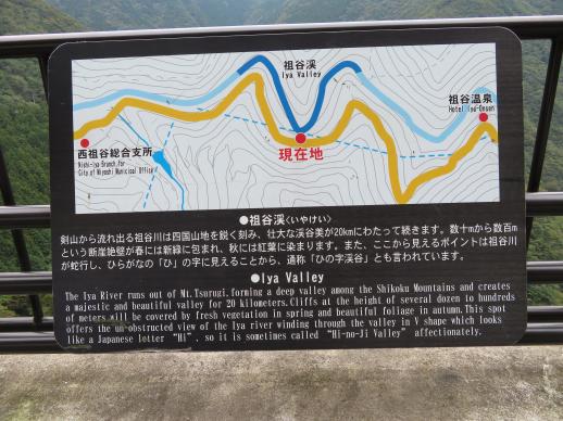
The Iya River Bend Observation Point is marked by a sign indicating the location and providing a little background information about the Iya River. "The Iya River runs out of Mt. Tsurugi, forming a deep valley among the Shikoku Mountains and creates a majestic and beautiful valley for 20 km/12.5 mi. Cliffs at the height of several dozen to hundreds of meters will be covered by fresh vegetation in spring and beautiful foliage in autumn. This spot offers the un-obstructed view of the Iya River winding through the valley in a "V" shape which looks like a Japanese letter "Hi", so it is sometimes called "Hi-no-Ji Valley affectionately."
Hours :
Open daily 24/7
Address :
Iya Valley, Miyoshi, Tokushima
9.1
km / 5.7
miles
-
(18
minutes)
MapCode :
357 483 299*58
Description :
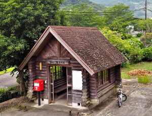
The Iyaguchi Station is used here only as a "way-point" for itineraries in Oboke and the Iya River Valley. There is limited parking but no rental car facilities here.
The Iyaguchi Station (祖谷口駅, Iyaguchi-eki) is a railway station on the Dosan Line in Miyoshi, Tokushima Prefecture. It is operated by JR Shikoku. The station, which is un-staffed, consists of a side platform serving a single track on a hillside. A flight of steps leads up to the platform from the access road. There is no station building but a log-style building at the base of the steps serves as a waiting room. A shelter is provided on the platform. The station opened on 28 November 1935 when the then Kōchi Line was extended northwards from Toyonaga to Minawa and the line was renamed the Dosan Line. At this time the station was operated by Japanese Government Railways, later becoming Japanese National Railways (JNR). With the privatization of JNR on 1 April 1987, control of the station passed to JR Shikoku.
Courtesy of Wikipedia
Address :
Yamashirocho Shimokawa, Miyoshi, Tokushima 779-5303